IMAGES TAKEN NEAR TO
Rookery Road, BEDFORD, MK44 3UG
Introduction
This page details the photographs taken nearby to Rookery Road, MK44 3UG by members of the Geograph project.
The Geograph project started in 2005 with the aim of publishing, organising and preserving representative images for every square kilometre of Great Britain, Ireland and the Isle of Man.

There are currently over 7.5m images from over14,400 individuals and you can help contribute to the project by visiting https://www.geograph.org.uk
Image Map
Images are licensed for reuse under creativecommons.org/licenses/by-sa/2.0
Notes
- Clicking on the map will re-center to the selected point.
- The higher the marker number, the further away the image location is from the centre of the postcode.
Image Listing (4 Images Found)
Images are licensed for reuse under creativecommons.org/licenses/by-sa/2.0
Image
Details
Distance
1
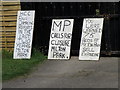
Local issues, Wyboston
Feelings running high in Wyboston village.
Image: © Michael Trolove
Taken: 24 Apr 2009
0.09 miles
3
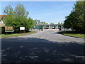
Haulage Yard, Wyboston
H E Payne a long standing haulage company operates from The Lane, Wyboston.
Image: © Michael Trolove
Taken: 24 Apr 2009
0.19 miles
4
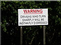
Take Heed
Simple message for all lorry drivers entering the H E Payne haulage yard. The reason is probably to protect trailer tyres particularly tri axles from scrubbing out on the concrete yard.
Image: © Michael Trolove
Taken: 24 Apr 2009
0.20 miles