IMAGES TAKEN NEAR TO
The Green, BEDFORD, MK44 3SU
Introduction
This page details the photographs taken nearby to The Green, MK44 3SU by members of the Geograph project.
The Geograph project started in 2005 with the aim of publishing, organising and preserving representative images for every square kilometre of Great Britain, Ireland and the Isle of Man.

There are currently over 7.5m images from over14,400 individuals and you can help contribute to the project by visiting https://www.geograph.org.uk
Image Map
Images are licensed for reuse under creativecommons.org/licenses/by-sa/2.0
Notes
- Clicking on the map will re-center to the selected point.
- The higher the marker number, the further away the image location is from the centre of the postcode.
Image Listing (24 Images Found)
Images are licensed for reuse under creativecommons.org/licenses/by-sa/2.0
Image
Details
Distance
1
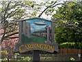
Cardington village sign
Depicting the church of St Mary the Virgin and the R101 airship. See http://www.geograph.org.uk/photo/4508858 for the nearby airship hangars at RAF Cardington.
Image: © Bikeboy
Taken: 30 May 2015
0.03 miles
4
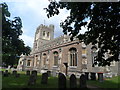
St Mary the Virgin, Cardington
The church was almost completely rebuilt between 1897-1901 but masonry from an earlier church has been incorporated. There are some C12 and C13 elements.
Image: © Bikeboy
Taken: 30 May 2015
0.06 miles
6
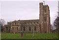
St Mary's Church, Cardington
This church is much more recent than initial impressions might suggest. Although the chancel dates from the early 13th century, the remainder of the church was built in 1901 through the generosity of the Whitbread family, who lived in nearby Southill.
Image: © Ian Capper
Taken: 13 Mar 2008
0.07 miles
7
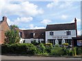
The Kings Arms, Cardington
Built in 1783, incorporating an earlier building. See http://www.britishlistedbuildings.co.uk/en-36661-the-kings-arms-public-house-cardington-#.VXCzLM9Viko for entry in British Listed Buildings.
Image: © Bikeboy
Taken: 30 May 2015
0.08 miles
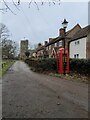
9
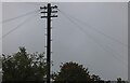
Traditional telegraph pole on Southill Road, Cardington
Image: © David Howard
Taken: 4 Oct 2020
0.08 miles
10
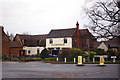
The Kings Arms, Cardington
A Grade II listed pub. Although the full history is unknown, the earliest licence record dates from 1822.
Image: © Ian Capper
Taken: 13 Mar 2008
0.08 miles