IMAGES TAKEN NEAR TO
Bedford Road, BEDFORD, MK44 3PP
Introduction
This page details the photographs taken nearby to Bedford Road, MK44 3PP by members of the Geograph project.
The Geograph project started in 2005 with the aim of publishing, organising and preserving representative images for every square kilometre of Great Britain, Ireland and the Isle of Man.

There are currently over 7.5m images from over14,400 individuals and you can help contribute to the project by visiting https://www.geograph.org.uk
Image Map
Images are licensed for reuse under creativecommons.org/licenses/by-sa/2.0
Notes
- Clicking on the map will re-center to the selected point.
- The higher the marker number, the further away the image location is from the centre of the postcode.
Image Listing (7 Images Found)
Images are licensed for reuse under creativecommons.org/licenses/by-sa/2.0
Image
Details
Distance
1
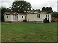
Interesting house
Built like a watermill, or converted from one
Image: © Oliver White
Taken: 23 Jun 2006
0.09 miles
2
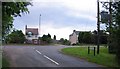
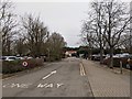
Mills Lane/Bedford Road Junction Willington
Image: © Andrew Tatlow
Taken: 4 Jun 2006
0.15 miles
3
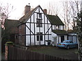
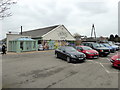
The Timbers, on Barford Road
Timber frame house at the 5-way junction of Wood Lane, Bedford, Sandy, Barford and Station Roads on the A603.
Image: © M J Richardson
Taken: 13 Dec 2014
0.16 miles
4
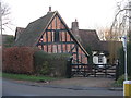
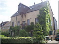
House at Willington
Brick and timber frame house at the 5-way junction of Wood Lane, Bedford, Sandy, Barford and Station Roads on the A603.
Image: © M J Richardson
Taken: 13 Dec 2014
0.18 miles