IMAGES TAKEN NEAR TO
The Ridgeway, BEDFORD, MK44 3PH
Introduction
This page details the photographs taken nearby to The Ridgeway, MK44 3PH by members of the Geograph project.
The Geograph project started in 2005 with the aim of publishing, organising and preserving representative images for every square kilometre of Great Britain, Ireland and the Isle of Man.

There are currently over 7.5m images from over14,400 individuals and you can help contribute to the project by visiting https://www.geograph.org.uk
Image Map
Images are licensed for reuse under creativecommons.org/licenses/by-sa/2.0
Notes
- Clicking on the map will re-center to the selected point.
- The higher the marker number, the further away the image location is from the centre of the postcode.
Image Listing (26 Images Found)
Images are licensed for reuse under creativecommons.org/licenses/by-sa/2.0
Image
Details
Distance
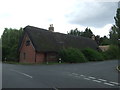
1
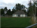
Bungalow near South Mills
Off The Ridgeway.
Image: © JThomas
Taken: 15 Aug 2015
0.00 miles
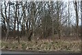
2
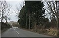
Heading north near South Mills
Towards Blunham.
Image: © JThomas
Taken: 15 Aug 2015
0.01 miles
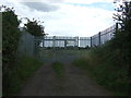
5
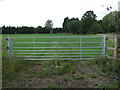
Field entrance near South Mills
Off The Ridgeway.
Image: © JThomas
Taken: 15 Aug 2015
0.03 miles
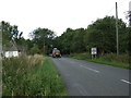
8
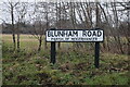
Sign for Blunham Road, Moggerhanger
All the maps use two Gs, this sign uses one.
Image: © David Howard
Taken: 30 Jan 2022
0.07 miles
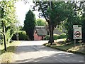
9
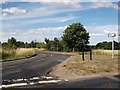
Junction of Blunham Road and Station Road near South Mills
Image: © John Brightley
Taken: 11 Jul 2010
0.13 miles