IMAGES TAKEN NEAR TO
Tempsford Road, BEDFORD, MK44 3NU
Introduction
This page details the photographs taken nearby to Tempsford Road, MK44 3NU by members of the Geograph project.
The Geograph project started in 2005 with the aim of publishing, organising and preserving representative images for every square kilometre of Great Britain, Ireland and the Isle of Man.

There are currently over 7.5m images from over14,400 individuals and you can help contribute to the project by visiting https://www.geograph.org.uk
Image Map
Images are licensed for reuse under creativecommons.org/licenses/by-sa/2.0
Notes
- Clicking on the map will re-center to the selected point.
- The higher the marker number, the further away the image location is from the centre of the postcode.
Image Listing (17 Images Found)
Images are licensed for reuse under creativecommons.org/licenses/by-sa/2.0
Image
Details
Distance
1
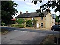
2-8 Tempsford Road, Blunham
Very attractive cottages at the edge of the village. According to the OS map,
this used to be a row of four cottages, which seem to have been converted to two. The early OS maps show an animal pound to the right of the houses.
Image: © John Brightley
Taken: 11 Jul 2010
0.01 miles
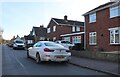
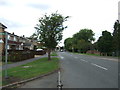
3
Bus stop and shelter on High Street, Blunham
Looking north.
Image: © JThomas
Taken: 15 Aug 2015
0.07 miles
4
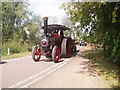
Traction engine in Blunham
Summer fayre - there were probably 25-30 steam-powered vehicles in the village
Image: © Oliver White
Taken: 24 Jun 2006
0.12 miles
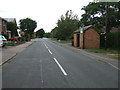
5
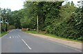
Blunham Bridge on Tempsford Road
Crossing the River Ivel
Image: © David Howard
Taken: 29 Aug 2021
0.14 miles
7
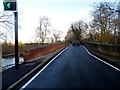
Car crossing Blunham Bridges
There are two bridges crossing the two channels of the River Ivel. This bridge is the older of the two-the west bridge. Its age is a matter of debate. It probably originates from the 17th or 18th century although there has been fairly continuous updating. A bridge over the river here first appears in a map of the manorial estate in 1719. See http://www.bedfordshire.gov.uk/CommunityAndLiving/ArchivesAndRecordOffice/CommunityArchives/Blunham/BlunhamBridges.aspx
Image: © Bikeboy
Taken: 22 Dec 2013
0.17 miles
8
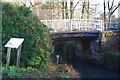
Blunham Navigation Bridge
This bridge was built in the early 19th century when a bypass channel was dug to make the River Ivel navigable past Blunham mill. I learnt this from the interpretation board standing next to it.
Image: © Ben Harris
Taken: 18 Feb 2012
0.19 miles
10
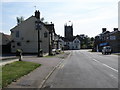
Two pubs and the Church, Blunham
High street scene in Blunham.
Image: © Michael Trolove
Taken: 24 Apr 2009
0.21 miles