IMAGES TAKEN NEAR TO
Roxton Road, BEDFORD, MK44 3LN
Introduction
This page details the photographs taken nearby to Roxton Road, MK44 3LN by members of the Geograph project.
The Geograph project started in 2005 with the aim of publishing, organising and preserving representative images for every square kilometre of Great Britain, Ireland and the Isle of Man.

There are currently over 7.5m images from over14,400 individuals and you can help contribute to the project by visiting https://www.geograph.org.uk
Image Map
Images are licensed for reuse under creativecommons.org/licenses/by-sa/2.0
Notes
- Clicking on the map will re-center to the selected point.
- The higher the marker number, the further away the image location is from the centre of the postcode.
Image Listing (9 Images Found)
Images are licensed for reuse under creativecommons.org/licenses/by-sa/2.0
Image
Details
Distance
2
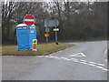
Junction of New Road and Roxton Road
An interesting place for a portable toilet.
Image: © Michael Trolove
Taken: 15 Jan 2010
0.13 miles
3
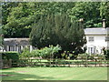
The back of "Lowlands" on the Bedford Road
Image: © Philip Jeffrey
Taken: 10 Jun 2015
0.13 miles
5
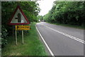
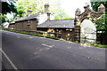
Bedford road heading towards Great Barford
Image: © Philip Jeffrey
Taken: 10 Jun 2015
0.16 miles
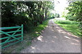
7
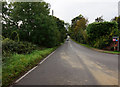
Farm Track towards the Ouse Valley Way
Image: © Philip Jeffrey
Taken: 10 Jun 2015
0.18 miles
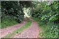
9
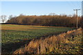
Field by Roxton Road
Woods round Great Barford House beyond
Image: © Philip Jeffrey
Taken: 14 Jan 2014
0.23 miles