IMAGES TAKEN NEAR TO
Barrance Way, BEDFORD, MK44 3FF
Introduction
This page details the photographs taken nearby to Barrance Way, MK44 3FF by members of the Geograph project.
The Geograph project started in 2005 with the aim of publishing, organising and preserving representative images for every square kilometre of Great Britain, Ireland and the Isle of Man.

There are currently over 7.5m images from over14,400 individuals and you can help contribute to the project by visiting https://www.geograph.org.uk
Image Map
Images are licensed for reuse under creativecommons.org/licenses/by-sa/2.0
Notes
- Clicking on the map will re-center to the selected point.
- The higher the marker number, the further away the image location is from the centre of the postcode.
Image Listing (19 Images Found)
Images are licensed for reuse under creativecommons.org/licenses/by-sa/2.0
Image
Details
Distance
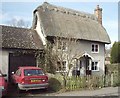
1
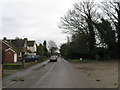
Housing in Moggerhanger
3 different houses in Moggerhanger. A beautiful thatched cottage hidden by a strange bungalow.
Image: © Jeff Tomlinson
Taken: 7 May 2007
0.06 miles
2
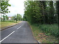
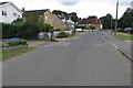
Park Lane, Moggerhanger
Road to Moggerhanger Park House.
Image: © Jeff Tomlinson
Taken: 7 May 2007
0.11 miles
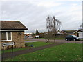
3
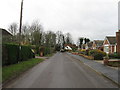
The Old Post Office
The Post Office used to be in the front room of this cottage. Just to the left of camera was the modern extension that used to be a Maid Marion general store.
Image: © Stephen Bashford
Taken: Unknown
0.15 miles
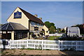
5
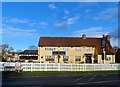
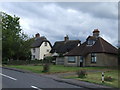
The Guinea pub, Moggerhanger
On the A603 Sandy-Bedford road
Image: © Bikeboy
Taken: 22 Dec 2013
0.16 miles
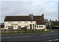
7
The Guinea
The Guinea public house in Moggerhanger.
Image: © Philip Halling
Taken: 26 May 2013
0.17 miles