IMAGES TAKEN NEAR TO
Colesden Road, BEDFORD, MK44 3BS
Introduction
This page details the photographs taken nearby to Colesden Road, MK44 3BS by members of the Geograph project.
The Geograph project started in 2005 with the aim of publishing, organising and preserving representative images for every square kilometre of Great Britain, Ireland and the Isle of Man.

There are currently over 7.5m images from over14,400 individuals and you can help contribute to the project by visiting https://www.geograph.org.uk
Image Map
Images are licensed for reuse under creativecommons.org/licenses/by-sa/2.0
Notes
- Clicking on the map will re-center to the selected point.
- The higher the marker number, the further away the image location is from the centre of the postcode.
Image Listing (11 Images Found)
Images are licensed for reuse under creativecommons.org/licenses/by-sa/2.0
Image
Details
Distance
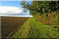
3
Footpath towards Roxton
Squashed between the two fences on the left
Image: © Philip Jeffrey
Taken: 14 Oct 2023
0.04 miles
4
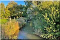
South Brook at the bottom of the field
You can just see the two steel bars, presumably the remnants of the bridge to take the footpath you can't get to over the brook
Image: © Philip Jeffrey
Taken: 14 Oct 2023
0.06 miles
7
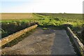
Farm track on a bridge over the brook
Image: © Philip Jeffrey
Taken: 14 Oct 2023
0.12 miles
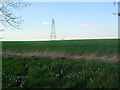
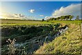
9
Wide open landscape, between Chawston and Colesden
Image: © Christopher Hilton
Taken: 20 Feb 2012
0.20 miles