IMAGES TAKEN NEAR TO
Renhold Road, BEDFORD, MK44 2RH
Introduction
This page details the photographs taken nearby to Renhold Road, MK44 2RH by members of the Geograph project.
The Geograph project started in 2005 with the aim of publishing, organising and preserving representative images for every square kilometre of Great Britain, Ireland and the Isle of Man.

There are currently over 7.5m images from over14,400 individuals and you can help contribute to the project by visiting https://www.geograph.org.uk
Image Map
Images are licensed for reuse under creativecommons.org/licenses/by-sa/2.0
Notes
- Clicking on the map will re-center to the selected point.
- The higher the marker number, the further away the image location is from the centre of the postcode.
Image Listing (21 Images Found)
Images are licensed for reuse under creativecommons.org/licenses/by-sa/2.0
Image
Details
Distance
1
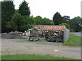
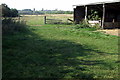
Timber yard at Home Farm
Some old and well seasoned timber at Renhold.
Image: © M J Richardson
Taken: 23 Jun 2011
0.06 miles
2
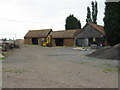
Timber clad buildings at Home Farm, Renhold
Image: © M J Richardson
Taken: 23 Jun 2011
0.08 miles
3
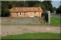
Timber yard at Home Farm
Though the timber in Image has gone now.
Image: © Philip Jeffrey
Taken: 23 Sep 2014
0.09 miles
5
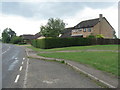
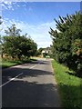
Houses on Ravensden Road, Renhold
Just south of Home Farm.
Image: © M J Richardson
Taken: 23 Jun 2011
0.13 miles