IMAGES TAKEN NEAR TO
Church Farm Lane, BEDFORD, MK44 2PF
Introduction
This page details the photographs taken nearby to Church Farm Lane, MK44 2PF by members of the Geograph project.
The Geograph project started in 2005 with the aim of publishing, organising and preserving representative images for every square kilometre of Great Britain, Ireland and the Isle of Man.

There are currently over 7.5m images from over14,400 individuals and you can help contribute to the project by visiting https://www.geograph.org.uk
Image Map
Images are licensed for reuse under creativecommons.org/licenses/by-sa/2.0
Notes
- Clicking on the map will re-center to the selected point.
- The higher the marker number, the further away the image location is from the centre of the postcode.
Image Listing (8 Images Found)
Images are licensed for reuse under creativecommons.org/licenses/by-sa/2.0
Image
Details
Distance
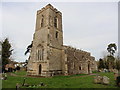
3
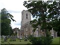
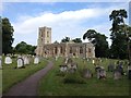
St Nicholas' church, Wilden
The church is almost entirely C15. However it contains a C13 piscina and the western half of the south wall of the nave dates from 1340 (see http://www.british-history.ac.uk/vch/beds/vol3/pp223-226#h3-0003). Fragments of the original C15 are present in some windows. The roof and font are both C15.
Image: © Bikeboy
Taken: 30 May 2015
0.18 miles
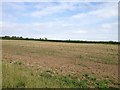
6
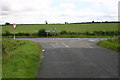
Shrubbery lane road junction
Shrubbery Lane junction with Wilden to Ravesden road
Image: © Shaun Ferguson
Taken: 12 Jul 2007
0.23 miles
7
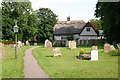
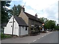
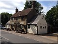
Wilden churchyard
Wilden churchyard path leads to the Victoria Arms pub
Image: © Shaun Ferguson
Taken: 12 Jul 2007
0.24 miles