IMAGES TAKEN NEAR TO
Begwary, BEDFORD, MK44 2NX
Introduction
This page details the photographs taken nearby to MK44 2NX by members of the Geograph project.
The Geograph project started in 2005 with the aim of publishing, organising and preserving representative images for every square kilometre of Great Britain, Ireland and the Isle of Man.

There are currently over 7.5m images from over14,400 individuals and you can help contribute to the project by visiting https://www.geograph.org.uk
Image Map
Images are licensed for reuse under creativecommons.org/licenses/by-sa/2.0
Notes
- Clicking on the map will re-center to the selected point.
- The higher the marker number, the further away the image location is from the centre of the postcode.
Image Listing (9 Images Found)
Images are licensed for reuse under creativecommons.org/licenses/by-sa/2.0
Image
Details
Distance
1
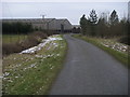
Lane at White House Farm
Lane passing White House Farm
Image: © Shaun Ferguson
Taken: 23 Feb 2010
0.05 miles
2
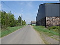
White House farm road frontage
Some very large farm building can be seen here.
Image: © Michael Trolove
Taken: 24 Apr 2009
0.05 miles
3
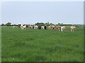
Cattle at White House Farm.
On their way to the farm for milking these cattle paused to take a look at the photographer.
Image: © Mike Fowkes
Taken: 12 May 2006
0.10 miles
4
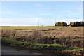
Fields in Begwary
Looking towards Begwary Lane from Staploe Road
Image: © David Howard
Taken: 19 Feb 2023
0.15 miles
5
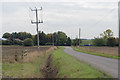
Unnamed Road, Leading to Staploe Road
Image: © Matthew Morgan
Taken: 23 Oct 2019
0.16 miles
6
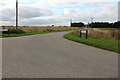
Begwary Lane
The village has a name but appears to consist of a farm seen on the right.
Image: © David Howard
Taken: 29 Aug 2021
0.21 miles
8
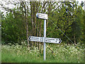
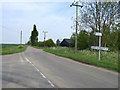
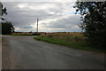
Signpost in the Bedfordshire countryside.
Image: © Mike Fowkes
Taken: 12 May 2006
0.23 miles