IMAGES TAKEN NEAR TO
Pertenhall Road, BEDFORD, MK44 2HR
Introduction
This page details the photographs taken nearby to Pertenhall Road, MK44 2HR by members of the Geograph project.
The Geograph project started in 2005 with the aim of publishing, organising and preserving representative images for every square kilometre of Great Britain, Ireland and the Isle of Man.

There are currently over 7.5m images from over14,400 individuals and you can help contribute to the project by visiting https://www.geograph.org.uk
Image Map
Images are licensed for reuse under creativecommons.org/licenses/by-sa/2.0
Notes
- Clicking on the map will re-center to the selected point.
- The higher the marker number, the further away the image location is from the centre of the postcode.
Image Listing (7 Images Found)
Images are licensed for reuse under creativecommons.org/licenses/by-sa/2.0
Image
Details
Distance
2
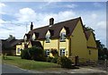
Chequers Public House
This is the Chequers Public House, the one remaining pub in Keysoe.
However it isn't always open.
Image: © JThomas
Taken: 13 Sep 2012
0.11 miles
3
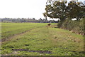
Scarecrow in field
Scarecrow in field next to Pertenhall Road Keysoe
Image: © Shaun Ferguson
Taken: 19 Oct 2007
0.13 miles
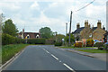
4
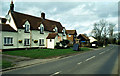
Brook End, Keysoe
Looking north along the B660 in Brook End, which is the northern end of Keysoe village. The pub is the Chequers Inn.
Image: © Stephen McKay
Taken: Unknown
0.14 miles