IMAGES TAKEN NEAR TO
Colley Close, BEDFORD, MK44 2HE
Introduction
This page details the photographs taken nearby to Colley Close, MK44 2HE by members of the Geograph project.
The Geograph project started in 2005 with the aim of publishing, organising and preserving representative images for every square kilometre of Great Britain, Ireland and the Isle of Man.

There are currently over 7.5m images from over14,400 individuals and you can help contribute to the project by visiting https://www.geograph.org.uk
Image Map
Images are licensed for reuse under creativecommons.org/licenses/by-sa/2.0
Notes
- Clicking on the map will re-center to the selected point.
- The higher the marker number, the further away the image location is from the centre of the postcode.
Image Listing (9 Images Found)
Images are licensed for reuse under creativecommons.org/licenses/by-sa/2.0
Image
Details
Distance
4
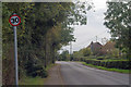
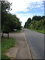
Church Road, Colmworth
Looking from Chapel End towards Church End.
Image: © Robin Webster
Taken: 12 Nov 2017
0.08 miles
5
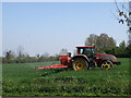
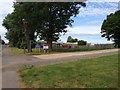
Fertilizer application, Colmworth
Nitrogen fertiliser being applied to Winter wheat with an air assisted spreader.
Image: © Michael Trolove
Taken: 24 Apr 2009
0.09 miles