IMAGES TAKEN NEAR TO
Traillys Close, MK44 2FR
Introduction
This page details the photographs taken nearby to Traillys Close, MK44 2FR by members of the Geograph project.
The Geograph project started in 2005 with the aim of publishing, organising and preserving representative images for every square kilometre of Great Britain, Ireland and the Isle of Man.

There are currently over 7.5m images from over14,400 individuals and you can help contribute to the project by visiting https://www.geograph.org.uk
Image Map
Images are licensed for reuse under creativecommons.org/licenses/by-sa/2.0
Notes
- Clicking on the map will re-center to the selected point.
- The higher the marker number, the further away the image location is from the centre of the postcode.
Image Listing (8 Images Found)
Images are licensed for reuse under creativecommons.org/licenses/by-sa/2.0
Image
Details
Distance
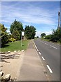
2
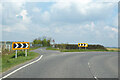
Junction of B660 Bedford Road and Graze Hill
The B660 swings round to the right towards Kimbolton.
Image: © Robin Webster
Taken: 2 May 2021
0.15 miles
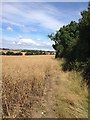
3
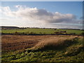
Hills to the back of Brickhill
View from the Cleat Hill to Graze Hill road, looking across to Clapham Park wood on the left horizon
Image: © Oliver White
Taken: 4 Dec 2005
0.17 miles
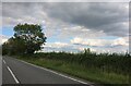
4
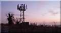
Phone mast near Cleat Hill
Sunset pic with the lights of Bedford in the background
Image: © Oliver White
Taken: 10 Dec 2005
0.19 miles
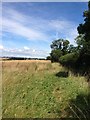
5

Phone mast near Cleat Hill
Taken from the bottom of the hill.
Image: © Dennis simpson
Taken: 28 May 2007
0.19 miles