IMAGES TAKEN NEAR TO
Church End, BEDFORD, MK44 2DA
Introduction
This page details the photographs taken nearby to Church End, MK44 2DA by members of the Geograph project.
The Geograph project started in 2005 with the aim of publishing, organising and preserving representative images for every square kilometre of Great Britain, Ireland and the Isle of Man.

There are currently over 7.5m images from over14,400 individuals and you can help contribute to the project by visiting https://www.geograph.org.uk
Image Map
Images are licensed for reuse under creativecommons.org/licenses/by-sa/2.0
Notes
- Clicking on the map will re-center to the selected point.
- The higher the marker number, the further away the image location is from the centre of the postcode.
Image Listing (31 Images Found)
Images are licensed for reuse under creativecommons.org/licenses/by-sa/2.0
Image
Details
Distance
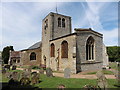
1
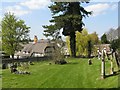
Church End, Thurleigh
The tower of St. Peter's beyond.
Image: © Jonathan Billinger
Taken: 27 Jul 2009
0.01 miles
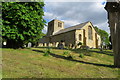
3
A view from St Peter's churchyard
Looking out towards the High Street.
Image: © M J Richardson
Taken: 22 Apr 2010
0.05 miles
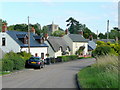
5
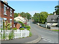
High Street, Thurleigh
Looking east from the Church End junction, with The Jackal pub on the left.
Image: © Jonathan Billinger
Taken: 27 Jul 2009
0.06 miles
6
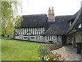
Large thatched house
On High Street, Thurleigh [for sale at the time of my visit].
Image: © M J Richardson
Taken: 22 Apr 2010
0.06 miles
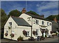
7
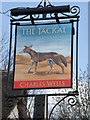
The Jackal pub sign
Thurleigh pub sign.
Image: © Michael Trolove
Taken: 10 Apr 2010
0.06 miles
8
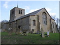
Thurleigh Church
The church has the appearance of being recently renovated with the stonework having been cleaned and pointed up.
Image: © Michael Trolove
Taken: 10 Apr 2010
0.08 miles