IMAGES TAKEN NEAR TO
Riverside View, BEDFORD, MK44 1SG
Introduction
This page details the photographs taken nearby to Riverside View, MK44 1SG by members of the Geograph project.
The Geograph project started in 2005 with the aim of publishing, organising and preserving representative images for every square kilometre of Great Britain, Ireland and the Isle of Man.

There are currently over 7.5m images from over14,400 individuals and you can help contribute to the project by visiting https://www.geograph.org.uk
Image Map
Images are licensed for reuse under creativecommons.org/licenses/by-sa/2.0
Notes
- Clicking on the map will re-center to the selected point.
- The higher the marker number, the further away the image location is from the centre of the postcode.
Image Listing (20 Images Found)
Images are licensed for reuse under creativecommons.org/licenses/by-sa/2.0
Image
Details
Distance
7
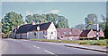
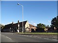
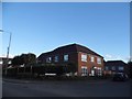
Milton Ernest, 1962: SE on A6, Rushden Road
View SE, towards Bedford, Luton and London, passing the Queen's Head. Compared to 50 years later, a rural retreat?
Image: © Ben Brooksbank
Taken: 4 Jun 1962
0.19 miles
8
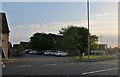
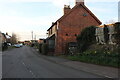
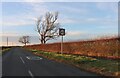
Bedford Road, Milton Ernest
Looking towards the Queen's Head Hotel car park
Image: © David Howard
Taken: 29 Jun 2019
0.20 miles