IMAGES TAKEN NEAR TO
Mill Road, BEDFORD, MK44 1NN
Introduction
This page details the photographs taken nearby to Mill Road, MK44 1NN by members of the Geograph project.
The Geograph project started in 2005 with the aim of publishing, organising and preserving representative images for every square kilometre of Great Britain, Ireland and the Isle of Man.

There are currently over 7.5m images from over14,400 individuals and you can help contribute to the project by visiting https://www.geograph.org.uk
Image Map
Images are licensed for reuse under creativecommons.org/licenses/by-sa/2.0
Notes
- Clicking on the map will re-center to the selected point.
- The higher the marker number, the further away the image location is from the centre of the postcode.
Image Listing (13 Images Found)
Images are licensed for reuse under creativecommons.org/licenses/by-sa/2.0
Image
Details
Distance
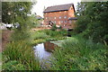
1
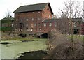
Sharnbrook Watermill
Restored & used as a local theatre.
Image: © Colin Mitchell
Taken: 11 Feb 2006
0.01 miles
2
Sharnbrook Industrial Estate - Mill Road
Image: © Colin Mitchell
Taken: 26 Sep 2006
0.01 miles
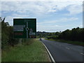
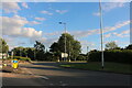
6
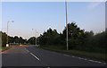
Roundabout on Bedford Road, Sharnbrook
Image: © David Howard
Taken: 29 Jun 2019
0.19 miles
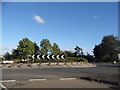
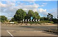
8
Roundabout on Bedford Road, Sharnbrook
Image: © David Howard
Taken: 11 Jul 2020
0.20 miles
9
Roundabout on Bedford Road, Sharnbrook
Image: © David Howard
Taken: 11 Jul 2020
0.20 miles