IMAGES TAKEN NEAR TO
Colworth Estate, BEDFORD, MK44 1LB
Introduction
This page details the photographs taken nearby to Colworth Estate, MK44 1LB by members of the Geograph project.
The Geograph project started in 2005 with the aim of publishing, organising and preserving representative images for every square kilometre of Great Britain, Ireland and the Isle of Man.

There are currently over 7.5m images from over14,400 individuals and you can help contribute to the project by visiting https://www.geograph.org.uk
Image Map
Images are licensed for reuse under creativecommons.org/licenses/by-sa/2.0
Notes
- Clicking on the map will re-center to the selected point.
- The higher the marker number, the further away the image location is from the centre of the postcode.
Image Listing (4 Images Found)
Images are licensed for reuse under creativecommons.org/licenses/by-sa/2.0
Image
Details
Distance
1
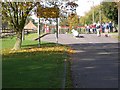
Security Gate
One of the entrances to the Colworth research establishment.
Image: © Kokai
Taken: 29 Oct 2006
0.14 miles
2
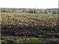
Colworth Laboratories
A top secret Unilever research establishment - the home of Nu-food. The chimney is on the boiler house which supplies steam for food processing. Colworth House itself is directly beyond the boiler house, obscured by trees.
Image: © Kokai
Taken: 29 Oct 2006
0.19 miles
3
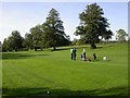
Colworth Golf Club
Part of a small golf course on the sports ground area - situated outside of the security zone. The facilities are mainly for the use of Unilever employees at Colworth.
Image: © Kokai
Taken: 29 Oct 2006
0.20 miles
4
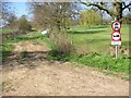
Yelnow Lane near Colworth Golf Club
The surface of the lane has improved since it was closed to wheeled traffic during winter months.
Image: © Will Lovell
Taken: 5 Apr 2007
0.24 miles