IMAGES TAKEN NEAR TO
Coxs Close, BEDFORD, MK44 1JU
Introduction
This page details the photographs taken nearby to Coxs Close, MK44 1JU by members of the Geograph project.
The Geograph project started in 2005 with the aim of publishing, organising and preserving representative images for every square kilometre of Great Britain, Ireland and the Isle of Man.

There are currently over 7.5m images from over14,400 individuals and you can help contribute to the project by visiting https://www.geograph.org.uk
Image Map
Images are licensed for reuse under creativecommons.org/licenses/by-sa/2.0
Notes
- Clicking on the map will re-center to the selected point.
- The higher the marker number, the further away the image location is from the centre of the postcode.
Image Listing (31 Images Found)
Images are licensed for reuse under creativecommons.org/licenses/by-sa/2.0
Image
Details
Distance
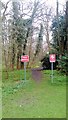
4
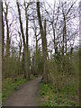
Mediaeval Earthworks in Castle Close Wildlife and Heritage Site
Image: © PAUL FARMER
Taken: 5 Apr 2015
0.12 miles
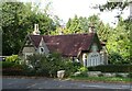
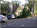
5
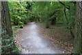
The Lodge Sharnbrook
This used to be the gateway to Colworth House.
Image: © PAUL FARMER
Taken: 11 Apr 2015
0.14 miles
7
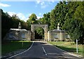
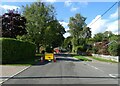
Twin Lodge - former gateway to Colworth House
Image: © JThomas
Taken: 23 Sep 2022
0.15 miles
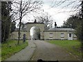
10
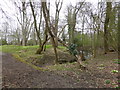
Colworth Gatehouse
Taken from within the grounds of Colworth near the main entrance to the estate.
Image: © Kokai
Taken: 29 Oct 2006
0.17 miles