IMAGES TAKEN NEAR TO
Church Lane, BEDFORD, MK44 1HT
Introduction
This page details the photographs taken nearby to Church Lane, MK44 1HT by members of the Geograph project.
The Geograph project started in 2005 with the aim of publishing, organising and preserving representative images for every square kilometre of Great Britain, Ireland and the Isle of Man.

There are currently over 7.5m images from over14,400 individuals and you can help contribute to the project by visiting https://www.geograph.org.uk
Image Map
Images are licensed for reuse under creativecommons.org/licenses/by-sa/2.0
Notes
- Clicking on the map will re-center to the selected point.
- The higher the marker number, the further away the image location is from the centre of the postcode.
Image Listing (38 Images Found)
Images are licensed for reuse under creativecommons.org/licenses/by-sa/2.0
Image
Details
Distance
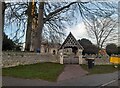
1
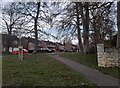
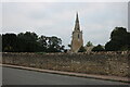
The Drive, Sharnbrook
The church is on the right.
Image: © David Howard
Taken: 19 Feb 2023
0.03 miles
2
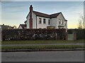
House on Church Lane, Sharnbrook
The extra wing on the right was added in 2009
Image: © David Howard
Taken: 19 Feb 2023
0.04 miles
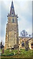
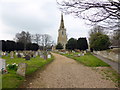
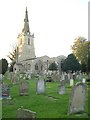
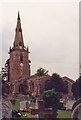
9
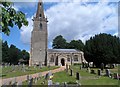
St Peter's Sharnbrook
Most of the church is C13. The tower is C14 and the roof was replaced in C17. Restoration was carried out in C19.
Image: © Bikeboy
Taken: 27 Jun 2015
0.06 miles