IMAGES TAKEN NEAR TO
Chapel Lane, BEDFORD, MK44 1HB
Introduction
This page details the photographs taken nearby to Chapel Lane, MK44 1HB by members of the Geograph project.
The Geograph project started in 2005 with the aim of publishing, organising and preserving representative images for every square kilometre of Great Britain, Ireland and the Isle of Man.

There are currently over 7.5m images from over14,400 individuals and you can help contribute to the project by visiting https://www.geograph.org.uk
Image Map
Images are licensed for reuse under creativecommons.org/licenses/by-sa/2.0
Notes
- Clicking on the map will re-center to the selected point.
- The higher the marker number, the further away the image location is from the centre of the postcode.
Image Listing (33 Images Found)
Images are licensed for reuse under creativecommons.org/licenses/by-sa/2.0
Image
Details
Distance
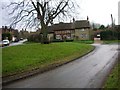
1
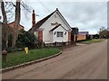
Wesleyan Methodist Chapel, Souldrop
The chapel is now a private house. The inscription above the door has a date of 1912.
Image: © N Avery
Taken: 29 Jan 2022
0.00 miles
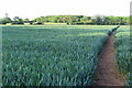
2
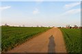
Footpath to Knotting Fox Farm from Chapel Lane
Image: © Philip Jeffrey
Taken: 27 May 2019
0.05 miles
3
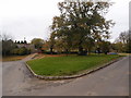
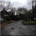
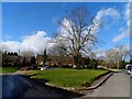
Village Green, Souldrop
One of two Greens in Souldrop.
Image: © Michael Trolove
Taken: 28 Oct 2012
0.11 miles
7
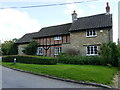
Lambs Cottage, Souldrop
Three buildings made into one https://historicengland.org.uk/listing/the-list/list-entry/1114296?section=official-list-entry
Image: © Jonathan Thacker
Taken: 16 Aug 2023
0.12 miles
8
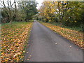
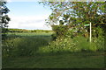
Forty Foot Lane
Near the village of Souldrop.
Image: © Michael Trolove
Taken: 28 Oct 2012
0.12 miles