IMAGES TAKEN NEAR TO
Hunters Yard, BEDFORD, MK44 1EN
Introduction
This page details the photographs taken nearby to Hunters Yard, MK44 1EN by members of the Geograph project.
The Geograph project started in 2005 with the aim of publishing, organising and preserving representative images for every square kilometre of Great Britain, Ireland and the Isle of Man.

There are currently over 7.5m images from over14,400 individuals and you can help contribute to the project by visiting https://www.geograph.org.uk
Image Map
Images are licensed for reuse under creativecommons.org/licenses/by-sa/2.0
Notes
- Clicking on the map will re-center to the selected point.
- The higher the marker number, the further away the image location is from the centre of the postcode.
Image Listing (8 Images Found)
Images are licensed for reuse under creativecommons.org/licenses/by-sa/2.0
Image
Details
Distance
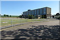
2
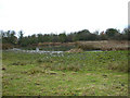
Disused Clay Quarry
On the site where the brickworks stood.
Image: © Kokai
Taken: 1 Jan 2006
0.09 miles
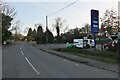
4
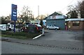
Petrol station on High Street, Riseley
This was UK petrol and a Daihatsu dealer before they pulled out of the UK.
Image: © David Howard
Taken: 19 Feb 2023
0.15 miles
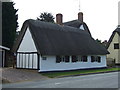
8
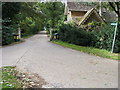
Bridleway to Sackville Cottage
Bridleway goes up the drive to Sackville Cottage
Image: © Shaun Ferguson
Taken: 4 Sep 2009
0.22 miles