IMAGES TAKEN NEAR TO
Rotten Row, BEDFORD, MK44 1EJ
Introduction
This page details the photographs taken nearby to Rotten Row, MK44 1EJ by members of the Geograph project.
The Geograph project started in 2005 with the aim of publishing, organising and preserving representative images for every square kilometre of Great Britain, Ireland and the Isle of Man.

There are currently over 7.5m images from over14,400 individuals and you can help contribute to the project by visiting https://www.geograph.org.uk
Image Map
Images are licensed for reuse under creativecommons.org/licenses/by-sa/2.0
Notes
- Clicking on the map will re-center to the selected point.
- The higher the marker number, the further away the image location is from the centre of the postcode.
Image Listing (9 Images Found)
Images are licensed for reuse under creativecommons.org/licenses/by-sa/2.0
Image
Details
Distance
2
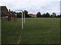
Riseley Playing Fields
Riseley Playing Fields looking to the Lower School on Church Lane
Image: © Shaun Ferguson
Taken: 4 Sep 2009
0.18 miles

4
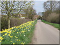
Springtime on the Butts
Butts lane leading to Rotten Row, Riseley
Image: © Michael Trolove
Taken: 10 Apr 2010
0.20 miles