IMAGES TAKEN NEAR TO
Bedford Road, BEDFORD, MK44 1EF
Introduction
This page details the photographs taken nearby to Bedford Road, MK44 1EF by members of the Geograph project.
The Geograph project started in 2005 with the aim of publishing, organising and preserving representative images for every square kilometre of Great Britain, Ireland and the Isle of Man.

There are currently over 7.5m images from over14,400 individuals and you can help contribute to the project by visiting https://www.geograph.org.uk
Image Map
Images are licensed for reuse under creativecommons.org/licenses/by-sa/2.0
Notes
- Clicking on the map will re-center to the selected point.
- The higher the marker number, the further away the image location is from the centre of the postcode.
Image Listing (9 Images Found)
Images are licensed for reuse under creativecommons.org/licenses/by-sa/2.0
Image
Details
Distance
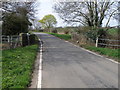
1
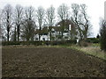
The Mallowry
From a bridleway south-west of the village of Riseley.
Image: © Kokai
Taken: 1 Jan 2006
0.07 miles
5
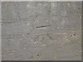
Bench Mark on the Bridge at Riseley
An OS bench mark in the middle of the bridge over the Cedar Brook Image
Image: © Michael Trolove
Taken: 10 Apr 2010
0.16 miles
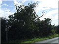
6
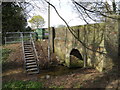
Level Station, Cedar Brook
An Environment Agency monitoring facility, hence the steps.
Image: © Michael Trolove
Taken: 10 Apr 2010
0.17 miles
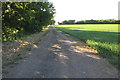
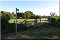
9
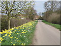
Springtime on the Butts
Butts lane leading to Rotten Row, Riseley
Image: © Michael Trolove
Taken: 10 Apr 2010
0.25 miles