IMAGES TAKEN NEAR TO
Litchfields, BEDFORD, MK44 1DN
Introduction
This page details the photographs taken nearby to Litchfields, MK44 1DN by members of the Geograph project.
The Geograph project started in 2005 with the aim of publishing, organising and preserving representative images for every square kilometre of Great Britain, Ireland and the Isle of Man.

There are currently over 7.5m images from over14,400 individuals and you can help contribute to the project by visiting https://www.geograph.org.uk
Image Map
Images are licensed for reuse under creativecommons.org/licenses/by-sa/2.0
Notes
- Clicking on the map will re-center to the selected point.
- The higher the marker number, the further away the image location is from the centre of the postcode.
Image Listing (32 Images Found)
Images are licensed for reuse under creativecommons.org/licenses/by-sa/2.0
Image
Details
Distance
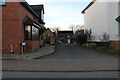
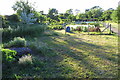
4
Footpath to Church Lane
From High Street footpath to Church Lane
Image: © Shaun Ferguson
Taken: 4 Sep 2009
0.04 miles
7
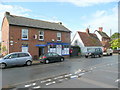
Riseley village stores
The village is not small, but there does not seem to be a post office here, despite the letter box.
Image: © Jonathan Billinger
Taken: 27 Jul 2009
0.08 miles


10
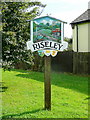
Riseley village sign
Commemorating the Queen's Golden Jubilee, 2002.
Image: © Jonathan Billinger
Taken: 27 Jul 2009
0.09 miles