IMAGES TAKEN NEAR TO
Yielden, BEDFORD, MK44 1AJ
Introduction
This page details the photographs taken nearby to MK44 1AJ by members of the Geograph project.
The Geograph project started in 2005 with the aim of publishing, organising and preserving representative images for every square kilometre of Great Britain, Ireland and the Isle of Man.

There are currently over 7.5m images from over14,400 individuals and you can help contribute to the project by visiting https://www.geograph.org.uk
Image Map
Images are licensed for reuse under creativecommons.org/licenses/by-sa/2.0
Notes
- Clicking on the map will re-center to the selected point.
- The higher the marker number, the further away the image location is from the centre of the postcode.
Image Listing (5 Images Found)
Images are licensed for reuse under creativecommons.org/licenses/by-sa/2.0
Image
Details
Distance
1
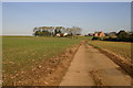
Farm road up to Manor Farm
Just above Middle Lodge the Farm road continues up to Manor Farm
Image: © Shaun Ferguson
Taken: 19 Oct 2007
0.03 miles
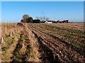
3
High Barn Farm and Manor Farm
Two farm names for what appears to be a single unit.
Image: © Michael Trolove
Taken: 9 Jan 2013
0.09 miles
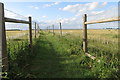
5
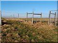
Public right of way intersection
A bridleway and footpath crossing point on the edge of Chelveston Airfield.
Image: © Michael Trolove
Taken: 9 Jan 2013
0.24 miles