IMAGES TAKEN NEAR TO
Portishead Drive, MILTON KEYNES, MK4 3FS
Introduction
This page details the photographs taken nearby to Portishead Drive, MK4 3FS by members of the Geograph project.
The Geograph project started in 2005 with the aim of publishing, organising and preserving representative images for every square kilometre of Great Britain, Ireland and the Isle of Man.

There are currently over 7.5m images from over14,400 individuals and you can help contribute to the project by visiting https://www.geograph.org.uk
Image Map
Images are licensed for reuse under creativecommons.org/licenses/by-sa/2.0
Notes
- Clicking on the map will re-center to the selected point.
- The higher the marker number, the further away the image location is from the centre of the postcode.
Image Listing (12 Images Found)
Images are licensed for reuse under creativecommons.org/licenses/by-sa/2.0
Image
Details
Distance
1
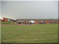
Giles Brook Primary School
The view from the very far side of the school field; the deputy head was very kind in letting me run over there to snap some shots of the school!
Image: © Mr Biz
Taken: 27 Jul 2006
0.07 miles

9
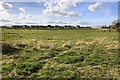
Looking across the pasture to Tattenhoe Park
Image: © Philip Jeffrey
Taken: 3 Apr 2020
0.23 miles