IMAGES TAKEN NEAR TO
Hengistbury Lane, MILTON KEYNES, MK4 3BF
Introduction
This page details the photographs taken nearby to Hengistbury Lane, MK4 3BF by members of the Geograph project.
The Geograph project started in 2005 with the aim of publishing, organising and preserving representative images for every square kilometre of Great Britain, Ireland and the Isle of Man.

There are currently over 7.5m images from over14,400 individuals and you can help contribute to the project by visiting https://www.geograph.org.uk
Image Map (18 Images)


Getting Data...Please wait
Leaflet Map data © OpenStreetMap
Images are licensed for reuse under creativecommons.org/licenses/by-sa/2.0
Notes
- Clicking on the map will re-center to the selected point.
- The higher the marker number, the further away the image location is from the centre of the postcode.
Image Listing (18 Images Found)
Images are licensed for reuse under creativecommons.org/licenses/by-sa/2.0
Image
Details
Distance
2
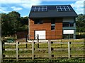
Howe Park Farm Cottage
An "eco" Passivhaus on the edge of Howe Park Wood. Built by the Parks Trust and rented out. You can see it under construction here Image
Image: © Philip Jeffrey
Taken: 29 Jul 2012
0.09 miles
3
New build by Howe Park Wood
A new eco house under construction on the edge of Howe Park Wood.
The completed building can be seen here: Image
Image: © Philip Jeffrey
Taken: 24 Feb 2012
0.09 miles
9
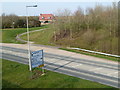
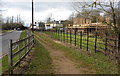
Sign of the times
It isn't often you find a new pub opening these days.
Image: © Malcolm Campbell
Taken: 29 Mar 2014
0.18 miles
10
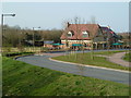
Another view of Prince George
Different view of the pub before the trees come into leaf.
Image: © Malcolm Campbell
Taken: 29 Mar 2014
0.18 miles