IMAGES TAKEN NEAR TO
Oxwich Grove, MILTON KEYNES, MK4 3BB
Introduction
This page details the photographs taken nearby to Oxwich Grove, MK4 3BB by members of the Geograph project.
The Geograph project started in 2005 with the aim of publishing, organising and preserving representative images for every square kilometre of Great Britain, Ireland and the Isle of Man.

There are currently over 7.5m images from over14,400 individuals and you can help contribute to the project by visiting https://www.geograph.org.uk
Image Map
Images are licensed for reuse under creativecommons.org/licenses/by-sa/2.0
Notes
- Clicking on the map will re-center to the selected point.
- The higher the marker number, the further away the image location is from the centre of the postcode.
Image Listing (13 Images Found)
Images are licensed for reuse under creativecommons.org/licenses/by-sa/2.0
Image
Details
Distance
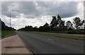
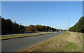
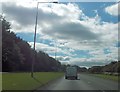
3
A421 Standing Way, Milton Keynes, heading north-east
Or H8 under the Milton Keynes road grid numbering system.
Image: © Robin Webster
Taken: 9 Jun 2019
0.12 miles
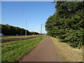
4
Windmill Hill Golf Centre
View from National Cycle Route 51.
Image: © JThomas
Taken: 21 Sep 2019
0.13 miles

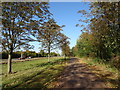
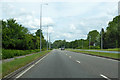
10
Standing Way approaching Rhoscolyn Drive
From the east
Image: © John Firth
Taken: 22 Sep 2013
0.19 miles