IMAGES TAKEN NEAR TO
Dodman Green, MILTON KEYNES, MK4 3AJ
Introduction
This page details the photographs taken nearby to Dodman Green, MK4 3AJ by members of the Geograph project.
The Geograph project started in 2005 with the aim of publishing, organising and preserving representative images for every square kilometre of Great Britain, Ireland and the Isle of Man.

There are currently over 7.5m images from over14,400 individuals and you can help contribute to the project by visiting https://www.geograph.org.uk
Image Map
Images are licensed for reuse under creativecommons.org/licenses/by-sa/2.0
Notes
- Clicking on the map will re-center to the selected point.
- The higher the marker number, the further away the image location is from the centre of the postcode.
Image Listing (11 Images Found)
Images are licensed for reuse under creativecommons.org/licenses/by-sa/2.0
Image
Details
Distance
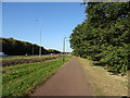
1
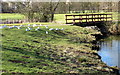
Footbridge in the linear park with seagulls
Image: © Philip Jeffrey
Taken: 24 Feb 2012
0.12 miles
2
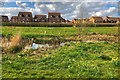
Houses looking in to Tattenhoe Valley Park
Image: © Philip Jeffrey
Taken: 4 Apr 2020
0.13 miles

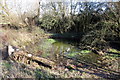
4
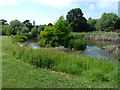
Loughton Valley Park, Tattenhoe, Milton Keynes
Image: © Cameraman
Taken: 28 Jun 2010
0.20 miles
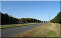
7
Rhoscolyn Drive junction with Standing Way
Standing Way is the A421
Image: © John Firth
Taken: 22 Sep 2013
0.21 miles
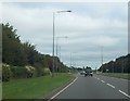
9
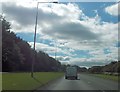
Standing Way approaching Rhoscolyn Drive
From the east
Image: © John Firth
Taken: 22 Sep 2013
0.22 miles