IMAGES TAKEN NEAR TO
Hoobury, BEDFORD, MK43 9QT
Introduction
This page details the photographs taken nearby to Hoobury, MK43 9QT by members of the Geograph project.
The Geograph project started in 2005 with the aim of publishing, organising and preserving representative images for every square kilometre of Great Britain, Ireland and the Isle of Man.

There are currently over 7.5m images from over14,400 individuals and you can help contribute to the project by visiting https://www.geograph.org.uk
Image Map
Images are licensed for reuse under creativecommons.org/licenses/by-sa/2.0
Notes
- Clicking on the map will re-center to the selected point.
- The higher the marker number, the further away the image location is from the centre of the postcode.
Image Listing (7 Images Found)
Images are licensed for reuse under creativecommons.org/licenses/by-sa/2.0
Image
Details
Distance
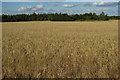
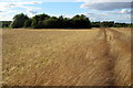
1
Flat and Boring
A rather flat field next to a rather flat road, approaching Wootton. A remarkably uninteresting grid square in Marston Vale.
Image: © Richard Schmidt
Taken: 16 Mar 2007
0.12 miles
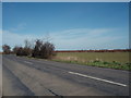
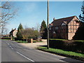
3
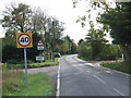
Cranfield Road, Wootton Green
Cranfield Road approaching the village of Wootton Green in Bedfordshire.
Image: © Malc McDonald
Taken: 20 Oct 2012
0.16 miles
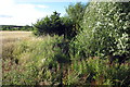
4
Path to Wootton by a stand of trees round a pond
Image: © Philip Jeffrey
Taken: 11 Aug 2013
0.18 miles
5
Wootton Green
A large house in Wootton Green.
Image: © Richard Schmidt
Taken: 16 Mar 2007
0.20 miles
6
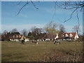
Horses and Houses
Horses grazing in the field next to houses in Wootton Green.
Image: © Richard Schmidt
Taken: 16 Mar 2007
0.21 miles