IMAGES TAKEN NEAR TO
Stevenson Walk, BEDFORD, MK43 9PT
Introduction
This page details the photographs taken nearby to Stevenson Walk, MK43 9PT by members of the Geograph project.
The Geograph project started in 2005 with the aim of publishing, organising and preserving representative images for every square kilometre of Great Britain, Ireland and the Isle of Man.

There are currently over 7.5m images from over14,400 individuals and you can help contribute to the project by visiting https://www.geograph.org.uk
Image Map
Images are licensed for reuse under creativecommons.org/licenses/by-sa/2.0
Notes
- Clicking on the map will re-center to the selected point.
- The higher the marker number, the further away the image location is from the centre of the postcode.
Image Listing (9 Images Found)
Images are licensed for reuse under creativecommons.org/licenses/by-sa/2.0
Image
Details
Distance
1
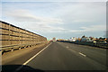
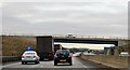
A421 towards Bedford
A noise fence for housing developments at Wootton is on the left.
Image: © Robin Webster
Taken: 9 Dec 2017
0.15 miles
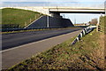
2
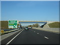
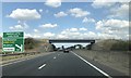
A421 passing under Fields Road
A new stretch of road opened December 2010.
Image: © Mr Ignavy
Taken: 28 Oct 2011
0.19 miles
6
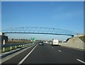
Bridge over A421, Wootton
Fields Road crosses.
Image: © Robin Webster
Taken: 9 Dec 2017
0.21 miles
7
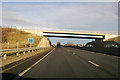
Fields Road to Wootton over Woburn Road
Image: © Philip Jeffrey
Taken: 7 Dec 2013
0.22 miles