IMAGES TAKEN NEAR TO
Hall End Road, BEDFORD, MK43 9HL
Introduction
This page details the photographs taken nearby to Hall End Road, MK43 9HL by members of the Geograph project.
The Geograph project started in 2005 with the aim of publishing, organising and preserving representative images for every square kilometre of Great Britain, Ireland and the Isle of Man.

There are currently over 7.5m images from over14,400 individuals and you can help contribute to the project by visiting https://www.geograph.org.uk
Image Map
Images are licensed for reuse under creativecommons.org/licenses/by-sa/2.0
Notes
- Clicking on the map will re-center to the selected point.
- The higher the marker number, the further away the image location is from the centre of the postcode.
Image Listing (8 Images Found)
Images are licensed for reuse under creativecommons.org/licenses/by-sa/2.0
Image
Details
Distance
1
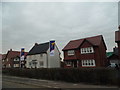
New houses on Hall End Road
More fields covered with housing for our rapidly growing population.
Image: © David Howard
Taken: 12 Mar 2017
0.05 miles
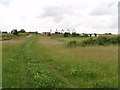
2
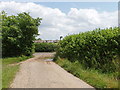
John Bunyan Trail enters Wootton
View from the footpath as it comes into Hall End, Wootton
Image: © David Hawgood
Taken: 20 Jun 2007
0.08 miles
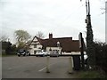
3
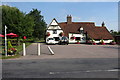
Chequers Inn and footpath into Wootton
Image: © Philip Jeffrey
Taken: 4 Sep 2013
0.09 miles
4
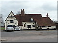
The Chequers Inn
The Chequers Inn, Hall End, near Wootton, Bedfordshire.
Image: © Richard Schmidt
Taken: 10 Mar 2007
0.11 miles
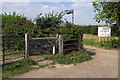
7
John Bunyan Trail at Hall End, Wootton
The John Bunyan Trail is a 75 mile circular path through places associated with John Bunyan.
Image: © David Hawgood
Taken: 20 Jun 2007
0.15 miles
8
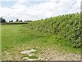
Pasture and hedge, Hall End of Wootton
A footpath runs up beside the hedge.
Image: © David Hawgood
Taken: 20 Jun 2007
0.16 miles