IMAGES TAKEN NEAR TO
Elmer Crescent, BEDFORD, MK43 9FU
Introduction
This page details the photographs taken nearby to Elmer Crescent, MK43 9FU by members of the Geograph project.
The Geograph project started in 2005 with the aim of publishing, organising and preserving representative images for every square kilometre of Great Britain, Ireland and the Isle of Man.

There are currently over 7.5m images from over14,400 individuals and you can help contribute to the project by visiting https://www.geograph.org.uk
Image Map (Loading...)


Getting Data...Please wait
Leaflet Map data © OpenStreetMap
Images are licensed for reuse under creativecommons.org/licenses/by-sa/2.0
Notes
- Clicking on the map will re-center to the selected point.
- The higher the marker number, the further away the image location is from the centre of the postcode.
Image Listing (6 Images Found)
Images are licensed for reuse under creativecommons.org/licenses/by-sa/2.0
Image
Details
Distance
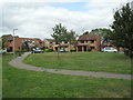
1
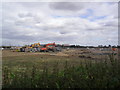
Wootton
Development near Wootton. Was like this; Image
Image: © Burgess Von Thunen
Taken: 14 Sep 2012
0.20 miles
3
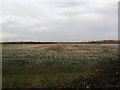
Farmland near Wootton
A field of stubble.
Image: © Burgess Von Thunen
Taken: 24 Nov 2011
0.21 miles
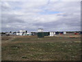
4
Haycroft
1990s houses in Wootton.
Image: © Burgess Von Thunen
Taken: 14 Sep 2012
0.22 miles
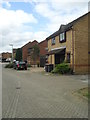
5
Grovebury Court
1990s houses in Wootton.
Image: © Burgess Von Thunen
Taken: 14 Sep 2012
0.24 miles
6
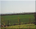
Bedford not Burnley.
These smoking chimneys look like a picture of a small northern industrial town in the 1950's but are in fact the brickworks near Bedford 2007.
Image: © Michael Wilson
Taken: 19 Apr 2007
0.24 miles