IMAGES TAKEN NEAR TO
Popes Way, BEDFORD, MK43 9DD
Introduction
This page details the photographs taken nearby to Popes Way, MK43 9DD by members of the Geograph project.
The Geograph project started in 2005 with the aim of publishing, organising and preserving representative images for every square kilometre of Great Britain, Ireland and the Isle of Man.

There are currently over 7.5m images from over14,400 individuals and you can help contribute to the project by visiting https://www.geograph.org.uk
Image Map
Images are licensed for reuse under creativecommons.org/licenses/by-sa/2.0
Notes
- Clicking on the map will re-center to the selected point.
- The higher the marker number, the further away the image location is from the centre of the postcode.
Image Listing (11 Images Found)
Images are licensed for reuse under creativecommons.org/licenses/by-sa/2.0
Image
Details
Distance
1
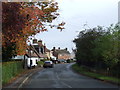
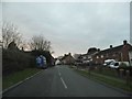
Church Road, Wootton
Church Road in the village of Wootton, near Bedford.
This image was taken on an afternoon in October. Leaves on the tree to the left of the image have turned gold and red.
Image: © Malc McDonald
Taken: 20 Oct 2012
0.19 miles
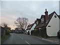
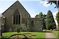
4
Wootton
A row of cottages with the parish church in the background, in the village of Wootton.
Image: © Richard Schmidt
Taken: 10 Mar 2007
0.20 miles
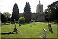
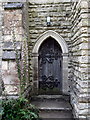
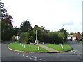
8
War Memorial
A war memorial, with the parish church in the background, Wootton.
Image: © Richard Schmidt
Taken: 10 Mar 2007
0.22 miles
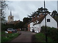
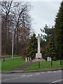
9
War Memorial, Wootton
A war memorial in the Bedfordshire village of Wootton.
Image: © Malc McDonald
Taken: 20 Oct 2012
0.23 miles
10
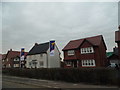
New houses on Hall End Road
More fields covered with housing for our rapidly growing population.
Image: © David Howard
Taken: 12 Mar 2017
0.24 miles