IMAGES TAKEN NEAR TO
Wood End Road, BEDFORD, MK43 9BB
Introduction
This page details the photographs taken nearby to Wood End Road, MK43 9BB by members of the Geograph project.
The Geograph project started in 2005 with the aim of publishing, organising and preserving representative images for every square kilometre of Great Britain, Ireland and the Isle of Man.

There are currently over 7.5m images from over14,400 individuals and you can help contribute to the project by visiting https://www.geograph.org.uk
Image Map
Images are licensed for reuse under creativecommons.org/licenses/by-sa/2.0
Notes
- Clicking on the map will re-center to the selected point.
- The higher the marker number, the further away the image location is from the centre of the postcode.
Image Listing (8 Images Found)
Images are licensed for reuse under creativecommons.org/licenses/by-sa/2.0
Image
Details
Distance
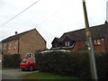
3
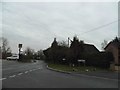
Wood End Lane at the junction of Tithe Road
For some reason a couple of miles of these roads weren't on Streetview. The junction was fairly easy to locate but the buildings will need an aerial check.
Image: © David Howard
Taken: 12 Mar 2017
0.10 miles
4
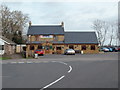
The Cross Keys
The Cross Keys, at Wood End, near Wootton.
Image: © Richard Schmidt
Taken: 10 Mar 2007
0.12 miles
6
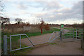
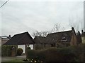
Buttons Ramsey Wood
An updated photograph taken 5 years after this one: Image
Image: © Mark Anderson
Taken: 28 Dec 2011
0.15 miles
7
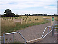
Buttons Ramsey
Recently planted woodland at Buttons Ramsey. This will form part of the Marston Vale Forest.
Image: © Mark Anderson
Taken: 29 Jul 2006
0.16 miles
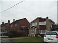
8
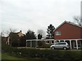
Houses on Wood End Road
For reasons unknown this whole road and a few nearby were not covered by Streetview.
Image: © David Howard
Taken: 12 Mar 2017
0.22 miles