IMAGES TAKEN NEAR TO
West End, Stagsden, BEDFORD, MK43 8SU
Introduction
This page details the photographs taken nearby to MK43 8SU by members of the Geograph project.
The Geograph project started in 2005 with the aim of publishing, organising and preserving representative images for every square kilometre of Great Britain, Ireland and the Isle of Man.

There are currently over 7.5m images from over14,400 individuals and you can help contribute to the project by visiting https://www.geograph.org.uk
Image Map
Images are licensed for reuse under creativecommons.org/licenses/by-sa/2.0
Notes
- Clicking on the map will re-center to the selected point.
- The higher the marker number, the further away the image location is from the centre of the postcode.
Image Listing (8 Images Found)
Images are licensed for reuse under creativecommons.org/licenses/by-sa/2.0
Image
Details
Distance
2
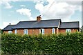
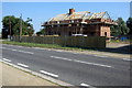
Astwood: 1 and 2, Ducksworth Cottages
Image: © Michael Garlick
Taken: 25 Jul 2023
0.00 miles
3
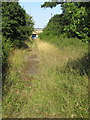
Footpath along the old Newport Pagnell Road
Image: © Philip Jeffrey
Taken: 5 Sep 2013
0.09 miles
4
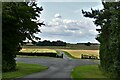
Astwood: The short road from the A422 lay-by then the track to Hill Farm
Image: © Michael Garlick
Taken: 25 Jul 2023
0.17 miles