IMAGES TAKEN NEAR TO
Batcheldor Gardens, BEDFORD, MK43 8SP
Introduction
This page details the photographs taken nearby to Batcheldor Gardens, MK43 8SP by members of the Geograph project.
The Geograph project started in 2005 with the aim of publishing, organising and preserving representative images for every square kilometre of Great Britain, Ireland and the Isle of Man.

There are currently over 7.5m images from over14,400 individuals and you can help contribute to the project by visiting https://www.geograph.org.uk
Image Map
Images are licensed for reuse under creativecommons.org/licenses/by-sa/2.0
Notes
- Clicking on the map will re-center to the selected point.
- The higher the marker number, the further away the image location is from the centre of the postcode.
Image Listing (12 Images Found)
Images are licensed for reuse under creativecommons.org/licenses/by-sa/2.0
Image
Details
Distance
6
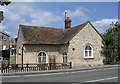
Tollhouse by Stagsden Road, Bromham parish
In the parish of Bromham (Bedford District), Toll House, No. 110, Stagsden Road, MK43 8QJ.
Grade II listed.
List Entry Number: 1321558 https://historicengland.org.uk/listing/the-list/list-entry/1321558
Surveyed
Milestone Society National ID: BD.BRO
Image: © Alan Rosevear
Taken: Unknown
0.16 miles
8
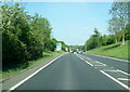
Junction on the A428, Bromham
Leading into the town centre
Image: © David Howard
Taken: 15 Oct 2017
0.19 miles
9
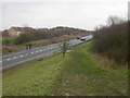
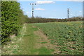
Intersection John Bunyan Trail and A428
South of Bromham, the outskirts of which can be seen on the other side of the A Road.
Image: © Kokai
Taken: 15 Jan 2006
0.21 miles