IMAGES TAKEN NEAR TO
Mordaunt Close, BEDFORD, MK43 8DR
Introduction
This page details the photographs taken nearby to Mordaunt Close, MK43 8DR by members of the Geograph project.
The Geograph project started in 2005 with the aim of publishing, organising and preserving representative images for every square kilometre of Great Britain, Ireland and the Isle of Man.

There are currently over 7.5m images from over14,400 individuals and you can help contribute to the project by visiting https://www.geograph.org.uk
Image Map
Images are licensed for reuse under creativecommons.org/licenses/by-sa/2.0
Notes
- Clicking on the map will re-center to the selected point.
- The higher the marker number, the further away the image location is from the centre of the postcode.
Image Listing (89 Images Found)
Images are licensed for reuse under creativecommons.org/licenses/by-sa/2.0
Image
Details
Distance
1
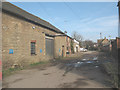
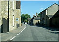
Bamford's Yard, Turvey
A view in the opposite direction, but of the same scene, as Image
Image: © Stephen Craven
Taken: 7 Mar 2009
0.04 miles
2
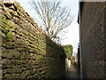
Footpath to Barncroft
The narrow, high-walled footpath leads off the village high street between buildings towards the modern housing estate called Barncroft.
Image: © Stephen Craven
Taken: 7 Mar 2009
0.05 miles
3
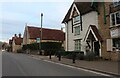
Village Shop,Turvey
Shop premises with character.
Image: © Michael Trolove
Taken: 25 Jan 2012
0.07 miles
4
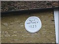
Wall plaque in May Road, Turvey
The House is called Lace Makers Cottage having been just that many years ago. The naive nature of the plaque raises a few smiles.
Image: © Jack Hill
Taken: 15 Oct 2001
0.07 miles
5
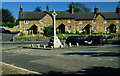
Turvey
This picture was taken from the church gate looking at the war memorial which is at the centre of the village.
Image: © Stephen McKay
Taken: Unknown
0.07 miles
6
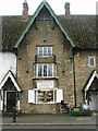
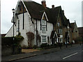
Village shop
A village shop with a bit of character.
Image: © Michael Trolove
Taken: 25 Jan 2012
0.08 miles
7
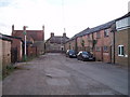
Bamfords Yard
Off Bamfords Lane, in Turvey (looking towards junction with main A-road, past the barrier)
Image: © Oliver White
Taken: 30 Jul 2006
0.08 miles
9
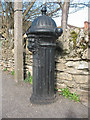
Standpipe in Turvey
I originally described this as a fire hydrant, but another contributor has sensibly suggested that it would be better described as a standpipe, intended for providing drinking water rather than firefighting.
This example is by Glenfield & Kennedy of Kilmarnock, a very respected name in waterworks fittings (their original works was demolished in 1982: see http://www.geographyhigh.connectfree.co.uk/prinayrskilmarnockglen.html , but the name Glenfield lives on as part of the AVK Group).
For a collection of photos and huge amounts of detail of similar fittings (in the UK and Spain) see http://thegreenlionproject.blogspot.com/
Image: © Stephen Craven
Taken: 7 Mar 2009
0.09 miles