IMAGES TAKEN NEAR TO
The Close, BEDFORD, MK43 8AT
Introduction
This page details the photographs taken nearby to The Close, MK43 8AT by members of the Geograph project.
The Geograph project started in 2005 with the aim of publishing, organising and preserving representative images for every square kilometre of Great Britain, Ireland and the Isle of Man.

There are currently over 7.5m images from over14,400 individuals and you can help contribute to the project by visiting https://www.geograph.org.uk
Image Map
Images are licensed for reuse under creativecommons.org/licenses/by-sa/2.0
Notes
- Clicking on the map will re-center to the selected point.
- The higher the marker number, the further away the image location is from the centre of the postcode.
Image Listing (8 Images Found)
Images are licensed for reuse under creativecommons.org/licenses/by-sa/2.0
Image
Details
Distance
2
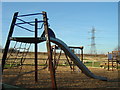
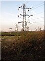
Play area, Newton Blossomville
Play area openened in January 2008 in the Millennium Wood which was planted in 2001. The pylons crossing in the background can be traced in other photos of the area.
Image: © sian harrison
Taken: 8 Feb 2008
0.07 miles
4
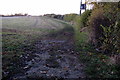
Ouse Valley Way leaving Newton Blossomville
Image: © Philip Jeffrey
Taken: 11 Nov 2012
0.11 miles
7
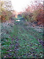
Part of the route of the Bedford Northampton line
Image: © Philip Jeffrey
Taken: 11 Nov 2012
0.16 miles