IMAGES TAKEN NEAR TO
Turvey, BEDFORD, MK43 8AA
Introduction
This page details the photographs taken nearby to MK43 8AA by members of the Geograph project.
The Geograph project started in 2005 with the aim of publishing, organising and preserving representative images for every square kilometre of Great Britain, Ireland and the Isle of Man.

There are currently over 7.5m images from over14,400 individuals and you can help contribute to the project by visiting https://www.geograph.org.uk
Image Map
Images are licensed for reuse under creativecommons.org/licenses/by-sa/2.0
Notes
- Clicking on the map will re-center to the selected point.
- The higher the marker number, the further away the image location is from the centre of the postcode.
Image Listing (8 Images Found)
Images are licensed for reuse under creativecommons.org/licenses/by-sa/2.0
Image
Details
Distance
1
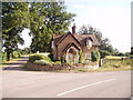
Lower Lodge of Turvey estate
Bridleway goes up the road visible on left of picture
Image: © Oliver White
Taken: 30 Jul 2006
0.12 miles
2
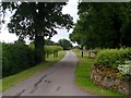
Private road which is a public bridleway to Turvey Hall
Image: © Bikeboy
Taken: 29 Jun 2013
0.12 miles
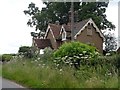
3
Dors Cottage
A wider view of the building shown in Image, named there as "Lower Lodge", and shown on the explorer map as "Lodge" but on the Landranger as "Turvey Cott[age]". But the actual name on the door is "Dors Cottage". The architectural style and location suggest that it was indeed a lodge to Turvey Hall.
Image: © Stephen Craven
Taken: 8 Mar 2009
0.14 miles
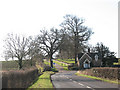
5
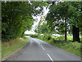
Road from Newton Blossomville to Turvey
Image: © Robin Webster
Taken: 4 Sep 2016
0.17 miles
6
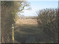
Start of the footpath to Turvey
A wooden marker post indicates the start of a footpath that runs south-north parallel to the surfaced bridleway for about 1km towards Turvey village. For a view further along the path see Image
Image: © Stephen Craven
Taken: 8 Mar 2009
0.20 miles
7
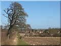
Footpath to Turvey (2)
An unusually broad margin of unploughed land has been left for walkers along the public footpath at the western edge of this field. A man is seen walking his dog southwards along it. See Image for the southern end of this footpath.
Image: © Stephen Craven
Taken: 8 Mar 2009
0.24 miles
8

Permissive footpath to Dors Cottage
The notice seen at the right of the photo declares the track to be a permissive footpath to Turvey Lodge (i.e. the building shown in Image) as part of a conservation project.
Image: © Stephen Craven
Taken: 8 Mar 2009
0.24 miles