IMAGES TAKEN NEAR TO
Pavenham Road, BEDFORD, MK43 7SY
Introduction
This page details the photographs taken nearby to Pavenham Road, MK43 7SY by members of the Geograph project.
The Geograph project started in 2005 with the aim of publishing, organising and preserving representative images for every square kilometre of Great Britain, Ireland and the Isle of Man.

There are currently over 7.5m images from over14,400 individuals and you can help contribute to the project by visiting https://www.geograph.org.uk
Image Map
Images are licensed for reuse under creativecommons.org/licenses/by-sa/2.0
Notes
- Clicking on the map will re-center to the selected point.
- The higher the marker number, the further away the image location is from the centre of the postcode.
Image Listing (14 Images Found)
Images are licensed for reuse under creativecommons.org/licenses/by-sa/2.0
Image
Details
Distance
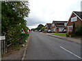
4
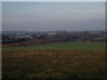
The edge of Oakley
Looking west from near the bridge carrying Highfield Road over the A6.
Image: © M J Richardson
Taken: 24 Jun 2011
0.18 miles
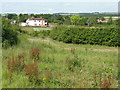
5
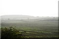
View from Oakley hill
Looking towards East End farm
Image: © Oliver White
Taken: 21 Nov 2005
0.18 miles
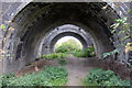
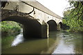
7
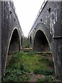
Pair of railway bridges go over the Great Ouse
Image: © Philip Jeffrey
Taken: 1 Oct 2014
0.20 miles
8
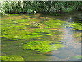
Going with the flow...
Water crowfoot on the River Great Ouse at Stafford Bridge. Rooted in the riverbed, the long filamentous stems and leaves follow the flow of water like green tresses of hair.
Image: © M J Richardson
Taken: 24 Jun 2011
0.21 miles
10
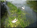
Parent swans and three cygnets
On the River Great Ouse at Stafford Bridge.
Image: © M J Richardson
Taken: 24 Jun 2011
0.22 miles