IMAGES TAKEN NEAR TO
Hunts Path, BEDFORD, MK43 7SR
Introduction
This page details the photographs taken nearby to Hunts Path, MK43 7SR by members of the Geograph project.
The Geograph project started in 2005 with the aim of publishing, organising and preserving representative images for every square kilometre of Great Britain, Ireland and the Isle of Man.

There are currently over 7.5m images from over14,400 individuals and you can help contribute to the project by visiting https://www.geograph.org.uk
Image Map
Images are licensed for reuse under creativecommons.org/licenses/by-sa/2.0
Notes
- Clicking on the map will re-center to the selected point.
- The higher the marker number, the further away the image location is from the centre of the postcode.
Image Listing (3 Images Found)
Images are licensed for reuse under creativecommons.org/licenses/by-sa/2.0
Image
Details
Distance
1
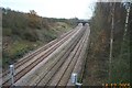
Oakley: Bedford to Wellingborough railway line
Viewed looking southwards from the Highfield Road overbridge, the distant twin arched bridge is the Railway Cottages bridge. The long since dismantled Oakley railway station was just beyond that bridge.
Image: © Nigel Cox
Taken: 14 Dec 2005
0.13 miles
2
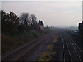
Railway cottages
From the bridge hidden behind Oakley's old railway station, which closed in 1958.
Image: © Oliver White
Taken: 21 Nov 2005
0.17 miles
3
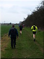
Bedford Clanger
A walker and runners taking part in the Bedford Clanger. 26 mile or 16 mile walk or run around Bedford.
Image: © Dennis simpson
Taken: 13 Mar 2011
0.19 miles