IMAGES TAKEN NEAR TO
Church Lane, BEDFORD, MK43 7RU
Introduction
This page details the photographs taken nearby to Church Lane, MK43 7RU by members of the Geograph project.
The Geograph project started in 2005 with the aim of publishing, organising and preserving representative images for every square kilometre of Great Britain, Ireland and the Isle of Man.

There are currently over 7.5m images from over14,400 individuals and you can help contribute to the project by visiting https://www.geograph.org.uk
Image Map
Images are licensed for reuse under creativecommons.org/licenses/by-sa/2.0
Notes
- Clicking on the map will re-center to the selected point.
- The higher the marker number, the further away the image location is from the centre of the postcode.
Image Listing (39 Images Found)
Images are licensed for reuse under creativecommons.org/licenses/by-sa/2.0
Image
Details
Distance
1
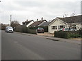
Church Lane, Oakley
A bungalow assortment.
Image: © M J Richardson
Taken: 21 Mar 2016
0.03 miles
2
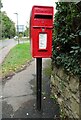
Elizabeth II postbox on Church Lane
Postbox No. MK43 370.
Image: © JThomas
Taken: 23 Sep 2022
0.09 miles
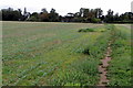
6
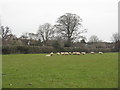
Sheep at Oakley
In pasture between church and Lovell Road.
Image: © M J Richardson
Taken: 21 Mar 2016
0.11 miles
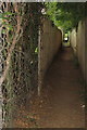
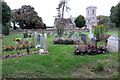
8
St Mary's Church, Oakley
Additional graveyard space.
Image: © Mr Biz
Taken: 22 Jun 2013
0.11 miles
10

St Mary's church clock, Oakley
Smartly gilded, and with lead coping to protect from the elements.
Image: © M J Richardson
Taken: 21 Mar 2016
0.12 miles