IMAGES TAKEN NEAR TO
Church Lane, BEDFORD, MK43 7PT
Introduction
This page details the photographs taken nearby to Church Lane, MK43 7PT by members of the Geograph project.
The Geograph project started in 2005 with the aim of publishing, organising and preserving representative images for every square kilometre of Great Britain, Ireland and the Isle of Man.

There are currently over 7.5m images from over14,400 individuals and you can help contribute to the project by visiting https://www.geograph.org.uk
Image Map
Images are licensed for reuse under creativecommons.org/licenses/by-sa/2.0
Notes
- Clicking on the map will re-center to the selected point.
- The higher the marker number, the further away the image location is from the centre of the postcode.
Image Listing (31 Images Found)
Images are licensed for reuse under creativecommons.org/licenses/by-sa/2.0
Image
Details
Distance

3
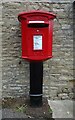
Elizabeth II postbox on High Street
Postbox No. MK41 123.
Image: © JThomas
Taken: 23 Sep 2022
0.04 miles
4
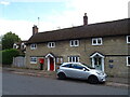
The Old Post Office on High Street
Showing position of Postbox No. MK43 123.
Image: © JThomas
Taken: 23 Sep 2022
0.04 miles
5
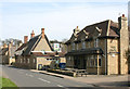
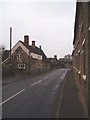
High Street, Pavenham
Most of the village is spread along High Street and looks like this.
Image: © David Kemp
Taken: 29 Mar 2014
0.11 miles