IMAGES TAKEN NEAR TO
Bridge End, BEDFORD, MK43 7HU
Introduction
This page details the photographs taken nearby to Bridge End, MK43 7HU by members of the Geograph project.
The Geograph project started in 2005 with the aim of publishing, organising and preserving representative images for every square kilometre of Great Britain, Ireland and the Isle of Man.

There are currently over 7.5m images from over14,400 individuals and you can help contribute to the project by visiting https://www.geograph.org.uk
Image Map
Images are licensed for reuse under creativecommons.org/licenses/by-sa/2.0
Notes
- Clicking on the map will re-center to the selected point.
- The higher the marker number, the further away the image location is from the centre of the postcode.
Image Listing (15 Images Found)
Images are licensed for reuse under creativecommons.org/licenses/by-sa/2.0
Image
Details
Distance
1
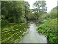
The River Great Ouse above Radwell Bridge
Looking upstream.
Image: © Jonathan Thacker
Taken: 17 Aug 2023
0.07 miles
2
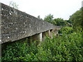
Radwell Bridge
Eighteenth century bridge partly obscured by modern footway https://historicengland.org.uk/listing/the-list/list-entry/1159240?section=official-list-entry
Image: © Jonathan Thacker
Taken: 17 Aug 2023
0.07 miles
3
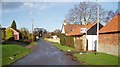
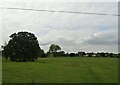
Radwell village
Looking down the northeasterly road in Radwell, with College Farm on the right
Image: © Oliver White
Taken: 2 Dec 2005
0.08 miles
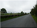
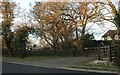
7
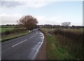
The road to Radwell
Road from Milton Earnest to Radwell, showing the depth markers (for when the road floods, they count up to 3 feet depth) and on the right-hand side of the road, an elevated walkway allowing you to walk across when it does flood (or to avoid splashing by cars)
On the horizon is Radwell, safely 9 feet above the wet fields
Image: © Oliver White
Taken: 2 Dec 2005
0.17 miles
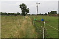
8
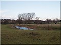
River Great Ouse by Radwell Bridge
Looking towards houses in Radwell (on the horizon), the river in the foreground is the River Great Ouse, flowing through its floodplain towards the Radwell Bridge (off to the left of this image)
Image: © Oliver White
Taken: 2 Dec 2005
0.18 miles