IMAGES TAKEN NEAR TO
Barley Kiln Lane, BEDFORD, MK43 7FB
Introduction
This page details the photographs taken nearby to Barley Kiln Lane, MK43 7FB by members of the Geograph project.
The Geograph project started in 2005 with the aim of publishing, organising and preserving representative images for every square kilometre of Great Britain, Ireland and the Isle of Man.

There are currently over 7.5m images from over14,400 individuals and you can help contribute to the project by visiting https://www.geograph.org.uk
Image Map
Images are licensed for reuse under creativecommons.org/licenses/by-sa/2.0
Notes
- Clicking on the map will re-center to the selected point.
- The higher the marker number, the further away the image location is from the centre of the postcode.
Image Listing (37 Images Found)
Images are licensed for reuse under creativecommons.org/licenses/by-sa/2.0
Image
Details
Distance
1
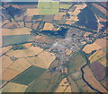
Harrold and Odell
With Grebe Lake of Harrold-Odell Country Park prominent at upper right, and the River Great Ouse flowing by on the right.
Image: © M J Richardson
Taken: 11 Jul 2018
0.02 miles
2
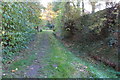
Footpath into the village by the stream
Image: © Philip Jeffrey
Taken: 5 Nov 2017
0.05 miles
3
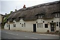
The Oakley Arms public house
Rather confusingly, Oakley is the name of a village a few miles down the road, but this pub is definitely in the village of Harrold.
Image: © Fractal Angel
Taken: 19 Aug 2007
0.05 miles
4
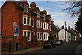
High Street, Harrold
This terrace of quite large Victorian houses represents yet another architectural style to be found in High Street. The picture was taken looking east towards Church Walk.
Image: © David Kemp
Taken: 17 Mar 2014
0.06 miles
5
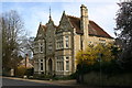
Harrold House, High Street, Harrold
"A tall, symmetrical Victorian-Jacobean villa" as Pevsner puts it.
Image: © David Kemp
Taken: 17 Mar 2014
0.08 miles

7
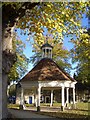
Harrold Market House
This early 18th-century octagonal market house on the village green is said to have been used for the marketing of local lace industry products and the distribution of thread and patterns. The building is Grade II listed.
Image: © Nigel Stickells
Taken: 9 Nov 2006
0.09 miles
8
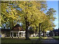
Harrold Village Green
The tree-lined village green includes a war memorial (not shown), an early 18th-century market house and a circular village lock-up built in 1824. The latter two are both Grade II listed.
Image: © Nigel Stickells
Taken: 9 Nov 2006
0.09 miles
9

The War Memorial and the Market Place, Harrold
Image: © Cameraman
Taken: 15 Apr 2010
0.09 miles
10
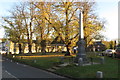
Harrold War Memorial and village green
Image: © Philip Jeffrey
Taken: 5 Nov 2017
0.10 miles