IMAGES TAKEN NEAR TO
Carlton Road, BEDFORD, MK43 7DT
Introduction
This page details the photographs taken nearby to Carlton Road, MK43 7DT by members of the Geograph project.
The Geograph project started in 2005 with the aim of publishing, organising and preserving representative images for every square kilometre of Great Britain, Ireland and the Isle of Man.

There are currently over 7.5m images from over14,400 individuals and you can help contribute to the project by visiting https://www.geograph.org.uk
Image Map
Images are licensed for reuse under creativecommons.org/licenses/by-sa/2.0
Notes
- Clicking on the map will re-center to the selected point.
- The higher the marker number, the further away the image location is from the centre of the postcode.
Image Listing (45 Images Found)
Images are licensed for reuse under creativecommons.org/licenses/by-sa/2.0
Image
Details
Distance

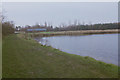
2
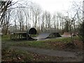
Skate park at Harrold-Odell Country Park
By the footpath that circles Grebe Lake.
Image: © M J Richardson
Taken: 28 Dec 2023
0.05 miles
3
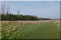
Wide path to the West of Grebe Lake, 1988
Image: © Mark Anderson
Taken: Unknown
0.07 miles
4
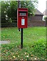
Elizabeth II postbox on Odell Road
Postbox No. MK43 75.
Image: © JThomas
Taken: 21 Sep 2022
0.10 miles

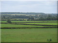
6
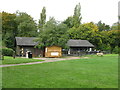
Visitor Centre
At Harrold-Odell Country Park - lakes, river, paths and nature reserve.
Image: © M J Richardson
Taken: 21 Sep 2017
0.11 miles
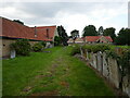
7
Visitors' Centre, Harrold-Odell Country Park, 1988
Image: © Mark Anderson
Taken: Unknown
0.11 miles
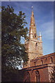
10
Looking across the flood plain of the Great Ouse towards St Peter's Church, Harrold
Image: © Bikeboy
Taken: 29 Jun 2013
0.13 miles