IMAGES TAKEN NEAR TO
The Green, BEDFORD, MK43 7DB
Introduction
This page details the photographs taken nearby to The Green, MK43 7DB by members of the Geograph project.
The Geograph project started in 2005 with the aim of publishing, organising and preserving representative images for every square kilometre of Great Britain, Ireland and the Isle of Man.

There are currently over 7.5m images from over14,400 individuals and you can help contribute to the project by visiting https://www.geograph.org.uk
Image Map
Images are licensed for reuse under creativecommons.org/licenses/by-sa/2.0
Notes
- Clicking on the map will re-center to the selected point.
- The higher the marker number, the further away the image location is from the centre of the postcode.
Image Listing (35 Images Found)
Images are licensed for reuse under creativecommons.org/licenses/by-sa/2.0
Image
Details
Distance

3
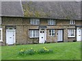
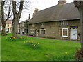
Spring on the Green, Harrold
Cottages at the edge of the village green at Harrold.
Image: © Cameraman
Taken: 15 Apr 2010
0.02 miles
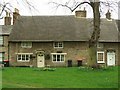
5
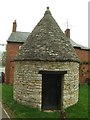
The Lock-up, Harrold
The old village lock-up was built in the early 19th century. It was used as a lock-up until late in the 19th century, thereafter it was used for storage.
Image: © Jeff Tomlinson
Taken: 14 Apr 2009
0.03 miles

8

The War Memorial and the Market Place, Harrold
Image: © Cameraman
Taken: 15 Apr 2010
0.04 miles
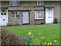
9
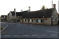
Thatched cottages near the "Butter Market"
The waste bins somewhat spoil the view.
Image: © Jeff Tomlinson
Taken: 14 Apr 2009
0.05 miles
10
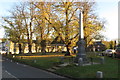
Harrold War Memorial and village green
Image: © Philip Jeffrey
Taken: 5 Nov 2017
0.05 miles