IMAGES TAKEN NEAR TO
Mansion Lane, BEDFORD, MK43 7BN
Introduction
This page details the photographs taken nearby to Mansion Lane, MK43 7BN by members of the Geograph project.
The Geograph project started in 2005 with the aim of publishing, organising and preserving representative images for every square kilometre of Great Britain, Ireland and the Isle of Man.

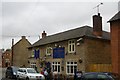
There are currently over 7.5m images from over14,400 individuals and you can help contribute to the project by visiting https://www.geograph.org.uk
Image Map
Images are licensed for reuse under creativecommons.org/licenses/by-sa/2.0
Notes
- Clicking on the map will re-center to the selected point.
- The higher the marker number, the further away the image location is from the centre of the postcode.
Image Listing (22 Images Found)
Images are licensed for reuse under creativecommons.org/licenses/by-sa/2.0
Image
Details
Distance
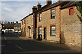
2
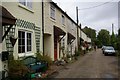
Entranceway to The Mansion, Harrold
This charming tree-lined driveway to The Mansion has entrance gates and piers that are Grade II listed. The gates are wrought iron with spearhead tops. The associated piers are incised with trefoil heads to each panel and they are surmounted by urn shaped finials.
Image: © Nigel Stickells
Taken: 9 Nov 2006
0.05 miles
3
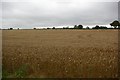
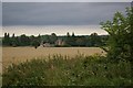
View across cornfield
Some borage is visible in the foreground.
Image: © Fractal Angel
Taken: 19 Aug 2007
0.07 miles
4
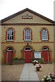
United Reformed Chapel
One of many chapels and churches in Harrold.
Image: © Fractal Angel
Taken: 19 Aug 2007
0.08 miles
5
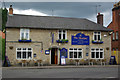
The Muntjac public house
This establishment boasts a Les Routiers recommendation as well as being AA 3-star. We didn't stop to look at the menu -- the drunken clientele including the man standing up and waving his arms in this picture rather put us off -- but it might be worth a look if you're ever Hungry in Harrold.
Image: © Fractal Angel
Taken: 19 Aug 2007
0.10 miles
6
View across field to Mansion House
The sky foretells the torrential downpour shortly to hit!
Image: © Fractal Angel
Taken: 19 Aug 2007
0.11 miles
7
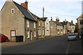
High Street, Harrold
As seen from opposite the United Reformed chapel looking east.
Image: © David Kemp
Taken: 17 Mar 2014
0.11 miles
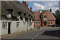
8
The Muntjac, Harrold
Attractive 17th century coaching inn. A black cloud looms overhead, but in fact there were no more than a few spots of rain. The name commemorates the Bedfordshire connection with muntjac deer, a far eastern species, brought to Woburn Park by the Duke of Bedford in the 19th century. Following an escape, these small deer (sometimes called 'barking deer') have spread across southern England as far west as the Welsh border and north to Derbyshire.
Image: © Stephen McKay
Taken: 17 Jun 2007
0.13 miles
9
High Street, Harrold
Looking west towards Brook Lane.
Image: © David Kemp
Taken: 17 Mar 2014
0.14 miles
10
The Oakley Arms, Harrold
Thatched inn dating back to the 16th century. It has a claim to fame; according to the pub's own website, Paul McCartney stopped off unexpectedly here in 1968 on a journey from Bradford to London, entertaining the locals on the piano late into the night. The building in the background is the Harrold Institute.
Image: © Stephen McKay
Taken: 17 Jun 2007
0.15 miles